
Welcome to the walking book on the web.
Welcome to the Cairngorms National Parks Living Walks book on the web, the all new interactive walking guide for the Cairngorms National Park published as a 320-page book with over 400 photos.

You are in Britain's “top” national park! -- If you live to walk, Living Walks is for you:
To the tenderfoot we aim to introduce some of the fairest routes in the Cairngorms, and with the time-served explorer we aim to share some of the most rewarding.
This guide is packed with dozens of trails for all, but the emphasis is on the large number of interesting family routes there are, in and around the towns and villages of the largest and most diverse of our national parks.
--------------------------------

--------------------------------

--------------------------------
Walking in the Cairngorms.

This book is profusely illustrated with excellent photographs, and the amount of research that must have gone into producing this little book is simply breathtaking.
‘Pocket gem for walkers’
Cameron McNeish.
--------------------------------------------------------------
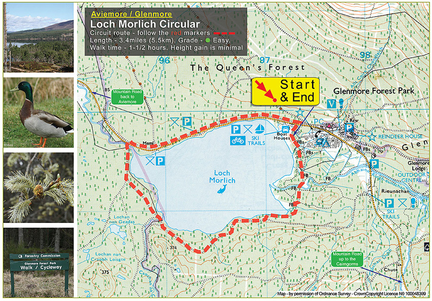
The guide has trail descriptions with lengths, grades and walk times including a pram and wheel chair guide, and a unique first for any walking book, is a 'noise indicator, which will help you gauge whether the walk is a quite tranquil one, or a nosy public trail. The book also has a dog-walking guide.
Living Walks is a practical guide aimed at any one who wants to get out and see just how stunning the UK's largest national park is. All the walks featured are based in and around the Cairngorms National Park's towns and villages with a mixture of easy family walks to challenging hill treks. Walks covered range from 500 metre loch side strolls to 7 mile plus hikes over moorland hills and through ancient pine forests.
Apart from a couple, all the walks listed are way-marked - this means the routes have been plotted with colour markers or number posts, which you simply follow as you go. However, as you are venturing into the countryside it's always a good idea to have a map to follow, regardless of what markers there are. This way you can plot your route and get a good sense of where you are.
Walking in the countryside is not the preserve of the chosen few, its something that every one can do. What you don't need to do is spend vast sums of money on walking aids like sat-nav paraphernalia, unless you're going to do long, unmarked, hill walks, then there is no room for complacency and thats when specialist gear is needed and you have to kit up with the works.
Never go out unprepared and, if in doubt, consult a specialist. And no matter where you walk, it's always a good idea to inform someone of your exact plans - leave details where they can be found, noting times, routes and who's in the group. What every length of walk you are undertaking, you should never head out without a map, and for long serious trails you will also need a compass and the skill to use it!.
For the internet, all the walks in the Living Walks book are accomponied by a detailed Ordnance Survey Explore based maps, with each trail marked out with walking data. Once you have logged on you can then download, free of charge, a walk-friendly map and print it off as often as you want.
--------------------------------------------------------------

--------------------------------------------------------------
--------------------------------------------------------------


--------------------------------------------------------------